Bad weather Kristin: When will it hit Attica
Διαβάζεται σε 6'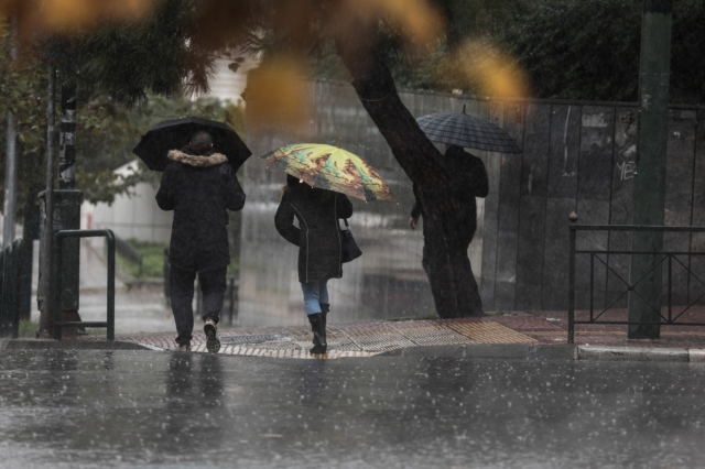
Severe weather “Kristin” is the name of the new low-pressure system set to hit the country. Which areas will be affected.
- 28 Ιανουαρίου 2026 23:01
Severe weather system “Kristin” is at the doorstep and is expected to affect the country for 24 hours, bringing intense weather phenomena.
This new low-pressure system is expected to impact Western Greece the most, however it will also briefly affect Attica around midday on Thursday.
In fact, on Wednesday (28/01) the Hellenic National Meteorological Service (EMY) issued an emergency weather deterioration bulletin, with an orange warning.
According to the bulletin, a temporary deterioration of the weather is forecast for tomorrow, Thursday (29/01), with heavy rain, thunderstorms and possibly local hailstorms, mainly in western Greece and the eastern island regions.
More specifically, locally heavy rain and thunderstorms are forecast:
On Thursday (29-01-26)
a. In the Ionian islands, Epirus, and western and central Sterea Greece from early morning until midday.
b. In western Peloponnese from the morning hours until late afternoon.
c. In Thrace from midday until the evening.
d. In the islands of the northern and eastern Aegean from the afternoon until late at night.
e. In Attica, briefly during the midday hours.
Through posts on Facebook, meteorologist Giorgos Tsatrafyllias sounded the “alarm bell” regarding the upcoming severe weather.
As he notes, the new low-pressure system is expected to cause problems both on land and at sea, with several areas falling within a zone of potential risk.
In a second post, he clarifies that the name “Kristin” was not given by EMY, but by the Portuguese Institute for Sea and Atmosphere (IPMA), as the system intensified over the western and central Mediterranean and was deemed capable of causing significant severe weather.
Civil Protection recommendations ahead of the weather deterioration
The General Secretariat for Civil Protection is issuing recommendations to citizens, urging them to be particularly cautious and to take self-protection measures against risks arising from the manifestation of intense weather phenomena.
As announced by the Fire Service, the operational plan for addressing risks from flooding and accompanying phenomena is being activated, while Fire Service units in areas where the phenomena are expected to occur have been placed on increased readiness and further escalation if required, in order to immediately deal with any problems caused by intense weather conditions associated with this severe weather system.
At the same time, the General Secretariat for Civil Protection of the Ministry of Climate Crisis and Civil Protection has informed the competent state services, as well as the regions and municipalities of the country, so that they are on increased civil protection readiness in order to immediately address the impacts of intense weather phenomena.
Specifically, in areas where heavy rainfall, thunderstorms or gale-force winds are forecast, the General Secretariat for Civil Protection recommends that citizens:
- Secure objects that could be swept away by intense weather phenomena and potentially cause damage or injury.
- Ensure that gutters and downspouts of residences are not blocked and are functioning properly.
- Avoid crossing torrents and streams, on foot or by vehicle, during thunderstorms and rainfall, as well as for several hours after their end. Particular caution is required at points of the road network where roads intersect with torrents and there is no bridge.
- Avoid outdoor work and activities in marine and coastal areas during intense weather phenomena (risk of lightning strikes).
- Take immediate shelter during a hailstorm. Seek refuge in a building or a vehicle and do not leave the safe space until you are sure that the storm has passed. Hailstorms can be very dangerous for animals as well.
- Avoid passing under large trees, hanging signs and generally areas where light objects (e.g. flower pots, broken glass, etc.) may become detached and fall to the ground (e.g. under balconies).
- Strictly follow the instructions of local competent authorities, such as the Traffic Police, etc.
In areas experiencing intense lightning activity:
If you are at home
- Do not hold electrical appliances or the telephone, as lightning can travel through cables. Disconnect television sets from the antenna and the power supply.
- Avoid touching plumbing pipes (kitchen, bathroom) as they are good conductors of electricity.
If you are in a vehicle
- Pull over to the side of the road and away from trees that could fall onto the vehicle.
- Stay inside and turn on hazard warning lights until the storm subsides.
- Close the windows and avoid touching metal objects.
- Avoid flooded roads.
If you are outdoors
- Seek shelter in a building or a vehicle; otherwise, sit immediately on the ground without lying down.
- Take shelter under dense branches of low trees if you are in a forest.
- Never seek shelter under a tall tree in an open area.
- Avoid low-lying areas due to the risk of flooding.
- Do not stand near pylons, power transmission lines, telephone lines and fences.
- Do not approach metal objects (e.g. cars, bicycles, camping equipment, etc.).
- Move away from rivers, lakes or other bodies of water.
- If you are in the sea, get out immediately.
If you are isolated in a flat area and feel your hair standing on end (a sign that lightning is imminent), crouch deeply with your head between your legs (to minimize your body’s surface area and contact with the ground), and throw away any metal objects you are carrying.
It is noted that according to the Emergency Weather Deterioration Bulletin (EDEK) issued today by the Hellenic National Meteorological Service (EMY), a temporary deterioration of the weather in the country is forecast for tomorrow, Thursday (29-01-2026), with heavy rain, thunderstorms and possibly local hailstorms, mainly in western Greece and the eastern island regions.
Citizens can stay informed daily about the evolution of extreme weather phenomena through the regular weather bulletins of EMY and on the EMY website at www.emy.gr
(www.oldportal.emy.gr).