Weather: Rain, Snow, and Cold in the Coming Hours – When the “Siberian Invasion” Arrives
Διαβάζεται σε 6'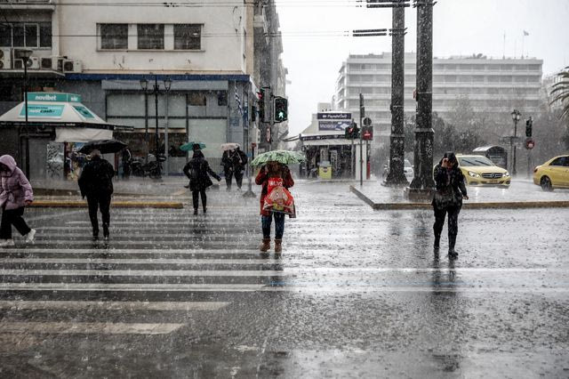
Rain, northern winds, and a drop in temperatures are expected in the coming hours. When will we see the biggest change in the weather, and how will the phenomena manifest?
- 18 Μαρτίου 2026 11:14
The weather began to deteriorate yesterday, Tuesday (March 17), and is expected to continue over the next few days, with the phenomena lasting at least until Saturday (March 21).
According to meteorologists, the major weather change will become noticeable on Thursday (March 19), with widespread rain and a drop in temperatures, with snow in various areas of the country.
“Siberian Invasion” According to Giorgos Tsatrafyllias – His Social Media Post
In a post on social media, meteorologist Giorgos Tsatrafyllias spoke about a “Siberian invasion” arriving on Thursday and discussed the “two faces” of the weather in the coming days. He wrote:
“Siberian invasion starting Thursday…”
Good afternoon!
The weather will have two faces in the coming period. There will also be increased Saharan dust. Specifically:
Tuesday-Wednesday
A low-pressure system named “Samuel” in the Gulf of Sirte will bring light rain to the Ionian and mainland areas, and thunderstorms to the Cyclades and Crete. Some snow will fall in the mountainous regions.
The temperature will drop by 2-3 degrees. Winds will blow from the east-northeast at up to 7 Beaufort.
Thursday-Saturday
Cold air masses from Siberia, combined with a new low-pressure system that will form off the Ionian coast, will bring more rain and snow.
On Thursday, the rain will be widespread, with stronger showers in the western and southern parts of Greece. Snowfall will be heavier in the mountainous areas and will briefly affect semi-mountainous areas by evening.
From Friday, the phenomena will be limited to the Aegean and especially Crete, and will weaken by Saturday.
The northern winds in the Aegean will reach up to 8 Beaufort.
The temperature will drop again by 5-6 degrees, and frost will form in mountainous areas. Indicatively, temperatures will reach 13-14 degrees Celsius around midday in Athens and Thessaloniki.
Note: These changes in the weather are neither extreme nor unprecedented. In fact, they are commonly seen during this period.
Thodoris Kolyda: “We Will Be Affected by Two Disturbances”
Meanwhile, meteorologist Thodoris Kolyda points out that from Tuesday, and especially from Thursday and Friday, rain and snow are expected across much of the country.
The two systems moving from the Gulf of Sirte and the Strait of Sicily will significantly affect many areas. According to Kolyda, there is a small but real chance that snow will reach semi-mountainous areas in central and northern Greece, while in the mountains, snowfall is almost certain and could be significant in some places.
On Tuesday and Wednesday, the rain will mostly be localized, but from Thursday onwards, it will become more widespread, affecting the Aegean and Crete. Winds in the Aegean will significantly intensify, reaching 8 Beaufort, increasing the feeling of cold.
The latest data indicates that the instability may continue after March 24, with new rain expected in many areas.
Weather for Tuesday, March 17
In Eastern Macedonia, Thrace, the eastern Aegean islands, and the Dodecanese, there will be some clouds which will gradually increase, with local rain expected in the southern islands of the eastern Aegean and the Dodecanese after midday. In the rest of the country, there will be increased clouds with local rain. Isolated thunderstorms will occur in the southern Ionian, Epirus, western Sterea, the Peloponnese, and Crete, mainly in the sea and coastal areas.
Visibility will be locally reduced in the morning and evening, especially in the Ionian and mainland areas.
Winds will be from the east at 4 to 6, locally 7, and in the southern Ionian up to 8 Beaufort.
The temperature will not change significantly and will reach 13-16°C in the north, 17-19°C in the rest of the areas, and locally 20°C in Crete and the Dodecanese.
MACEDONIA, THRACE
Weather: A few clouds that will quickly increase in Western Macedonia and gradually in the rest of the areas. Local rain will occur from the morning in Western and Central Macedonia.
Winds: From the east at 3-5, in the eastern sea and coastal areas 4-5, and from midday up to 6, gradually increasing to 7 Beaufort.
Temperature: From 3°C to 15°C, with a 2-4°C decrease in Western Macedonia.
IONIAN ISLANDS, EPIRUS, WESTERN STEREA, WESTERN PELOPONNESE
Weather: Increased clouds with local rain.
Winds: From the east at 4-6, locally 7 in the Ionian, and up to 8 Beaufort in the south.
Temperature: From 7°C to 17°C, 3-4°C lower in the interior of Epirus.
THESSALY, EASTERN STEREA, EVIA, EASTERN PELOPONNESE
Weather: A few clouds that will quickly increase in the eastern Peloponnese and gradually in the rest of the areas, leading to local rain.
Winds: From the northeast at 4-5, and in the south sea-coastal areas, from the evening also in the north 6-7 Beaufort.
Temperature: From 5°C to 16°C.
CYCLADES, CRETE
Weather: Initially in Crete and gradually in the Cyclades, there will be clouds with local rain.
Winds: From the northeast at 4-5, and from the afternoon in Crete, up to 6-7 Beaufort.
Temperature: From 11°C to 18°C.
EASTERN AEGEAN ISLANDS – DODECANESE
Weather: Scattered clouds which will increase from midday, with local rain starting in the south and later in the north.
Winds: In the north, northeast at 4-6, and from the afternoon locally 7 Beaufort. In the south, initially from the north at 3-4, gradually shifting to southeast at 4-5 Beaufort, strengthening slightly in the evening.
Temperature: From 11°C to 18°C, 2-3°C lower in the north.
ATTICA
Weather: Scattered clouds that will quickly increase, with local rain expected by the afternoon.
Winds: From the north-northeast at 4-5 Beaufort.
Temperature: From 5°C to 16°C.
THESSALONIKI
Weather: A few clouds which will gradually increase, with local rain expected by midday.
Winds: From the southeast at 3-4 Beaufort.
Temperature: From 4°C to 15°C.