Which areas will see snow settling – What to expect from snowfall in Attica
Διαβάζεται σε 13'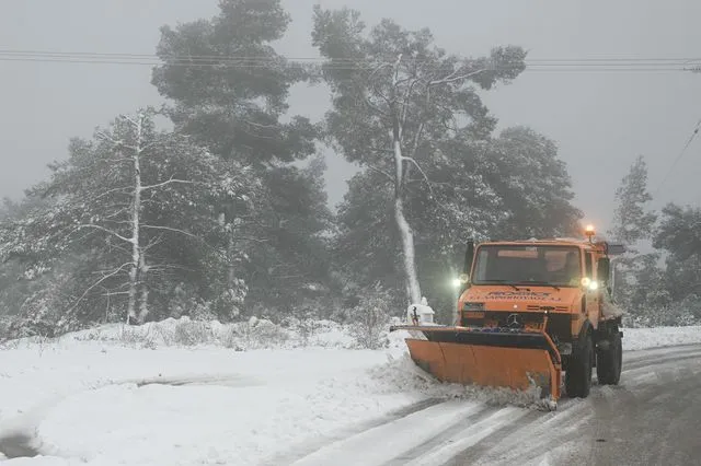
A gradual deterioration of the weather is forecast from Sunday afternoon, with an intense cold wave, strong winds and snowfall. The forecast by Kostas Lagouvardos, the HNMS emergency weather bulletin and the recommendations of the Civil Protection authorities. Detailed weather forecast.
- 11 Ιανουαρίου 2026 16:26
The state apparatus has been placed on high alert due to the approaching cold wave expected over the next three days. For this reason, the Hellenic National Meteorological Service (HNMS) has issued an emergency weather deterioration bulletin.
According to the service, a gradual worsening of weather conditions is forecast from this afternoon (Sunday, 11 January 2026), with an intense cold wave, strong northerly winds and snowfall in mountainous and semi-mountainous areas, as well as in lowland regions mainly in northern Greece.
Very low temperatures are expected to persist until Wednesday morning (14 January 2026).
Frost, locally severe in northern areas, will occur mainly during the morning and evening hours.
Very strong to gale-force northerly winds will blow in places until the evening hours of Monday (12 January 2026).
Snowfall is expected:
a. In the mountainous and semi-mountainous areas of mainland Greece and Evia.
b. From tonight in lowland areas of the Region of Eastern Macedonia and Thrace, in the regional units of Serres and Halkidiki, the eastern parts of the Thessaloniki regional unit, as well as on islands of the northern Aegean (Lemnos, Lesvos, Chios, Sporades).
c. From early Monday morning in lowland areas of Evia (mainly its eastern parts) and in the mountainous and semi-mountainous areas of the Cyclades and Crete. Snowfall will stop before midday on Monday (12 January 2026) in northern regions and from the afternoon hours in the rest of the country, except for the mountainous and semi-mountainous areas of Crete, where it will continue until Tuesday morning (13 January 2026).
The forecast by Kostas Lagouvardos – What to expect in Attica
Speaking to Orange Press Agency, the Director of Research at the National Observatory of Athens, Kostas Lagouvardos, analysed the evolution of the severe weather, stressing that it will affect the entire country.
“We will have a cold intrusion that will impact the whole of Greece. It will start to be felt in northern parts of the country from Sunday and will affect the entire country on Monday and Tuesday,” Mr Lagouvardos initially noted.
Elaborating on the areas where the first intense phenomena will occur, he said: “From Sunday night into Monday, we will see snowfall at low altitudes in areas such as eastern Thessaloniki, Halkidiki, parts of Xanthi, Thasos and Kavala. So snowfall will occur even at low elevations in these regions.”
The phenomena will then move further south. “We will also see snow in parts of the Sporades, in Evia—mainly central and southern Evia, in mountainous areas—, in the mountainous and semi-mountainous areas of the Cyclades, meaning islands with relatively high elevations, and from Monday onwards in Crete as well, in mountainous and semi-mountainous regions,” the Director of Research at the National Observatory of Athens added.
Mr Lagouvardos made special reference to Attica and Eastern Central Greece, clarifying whether snow accumulation problems are expected. “As far as Attica and Boeotia, generally eastern Central Greece, are concerned, we will have some sleet or snow from Sunday night into Monday. However, we estimate that overall amounts will not be large and will not cause snow accumulation problems,” he explained, adding with regard to the Athens basin:
“In Attica, snowfall and snow accumulation will occur, as mentioned, on Mount Parnitha and Mount Penteli. We expect to see a few snowflakes and generally weak phenomena in the northern parts of the basin, mainly in the northern and eastern areas, but our assessment is that the amounts from Sunday to Monday will not be sufficient to cause problems due to snow accumulation.”
Greater caution is required, however, in Evia. As Mr Lagouvardos underlined: “In central Evia in particular, which requires attention, due to low temperatures we will see snowfall down to very low altitudes, even in lowland areas.”
Referring to the national road network, he added: “Generally in the regions of Fthiotida and Boeotia and along the national axis, we will see occasional snowfall during the night, but as in Attica, we estimate that the amounts will be small and will therefore not cause snow accumulation problems.”
Finally, Mr Lagouvardos focused on the polar temperatures expected to prevail. “Another key feature of the weather, especially on Monday, will be very low temperatures across the country, with all-day frost—meaning frost throughout the entire 24-hour period—in parts of Western Macedonia, and very severe frost during the morning hours on both Tuesday and Wednesday.”
The good news comes from midweek onwards. “From Wednesday onward, temperatures will begin to rise and by the end of the week they will return to normal levels, slightly above average,” he concluded.
Risk Assessment Committee convened – Guidelines for citizens
It is noted that earlier, the Secretary General for Civil Protection, Nikos Papaefstathiou, convened the Risk Assessment Committee.
The National Coordination Centre for Operations and Crisis Management (ESKEDIK) is already in contact with first- and second-tier local authorities, as well as all relevant agencies, to ensure they have full information on the upcoming weather phenomena and can be placed on operational readiness if required. At the same time, the General Secretariat for Civil Protection urges citizens to be particularly cautious and to take self-protection measures against risks arising from severe weather conditions.
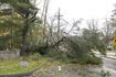
In areas where heavy rainfall, thunderstorms or gale-force winds are forecast:
- Secure objects which, if swept away by severe weather, could cause damage or injuries.
- Ensure that gutters and downspouts on homes are not blocked and are functioning properly.
- Avoid crossing torrents and streams, on foot or by vehicle, during storms and heavy rainfall, as well as for several hours after they have ended. Particular caution is required at points of the road network where roads intersect with torrents and there is no bridge.
- Avoid outdoor work and activities in marine and coastal areas during severe weather (risk of lightning strikes).
- Take immediate shelter during hailstorms. Seek refuge in a building or vehicle and do not leave the safe area until it is certain the storm has passed. Hail can also be very dangerous for animals.
- Avoid passing under large trees, suspended signs and, in general, areas where light objects (e.g. flower pots, broken glass, etc.) may become detached and fall (such as beneath balconies).
- Strictly follow the instructions of the competent local authorities, such as the Traffic Police.
In areas where snowfall and frost are forecast:
If travelling by car:
- Stay informed about weather conditions and the state of the road network.
- Carry snow chains in the vehicle and keep the fuel tank full.
- Travel only if necessary, preferably during daylight hours, using main roads.
- Inform relatives or acquaintances of the route to be taken.
- Adjust travel plans to avoid peak periods of severe weather.
- Strictly follow the instructions of the competent local authorities, such as the Traffic Police.
If travelling on foot:
- Dress in multiple layers of light clothing rather than one heavy garment, and wear appropriate footwear to avoid injuries due to slippery conditions.
- Avoid unnecessary movement during peak weather conditions (heavy snowfall, frost).
- For information and announcements regarding current conditions and road accessibility due to flooding or snowfall and frost, citizens can visit the Hellenic Police website at www.astynomia.gr.
For further information and self-protection guidelines related to severe weather phenomena, citizens can visit the website of the General Secretariat for Civil Protection at civilprotection.gov.gr.
Forecast for Sunday 11/01/2026
Increased cloud cover with local rainfall and, in western areas and the eastern Aegean, scattered thunderstorms, possibly locally strong in the Dodecanese.
Snowfall is expected in mountainous and northern semi-mountainous areas, while from the evening hours snow is also likely in parts of northeastern Greece at lower altitudes.
Winds in the south will blow from westerly directions at 5 to 7 Beaufort, locally reaching 8 Beaufort over the seas in the morning. In the north, winds will be northerly at 4 to 6 Beaufort, gradually strengthening to 5 to 7 Beaufort and locally up to 8 Beaufort in the northern Aegean during the evening.
Temperatures will drop noticeably in the north, where they will not exceed 6 to 8°C. In the rest of the country, temperatures will range from 9 to 15°C, while in the Cyclades, Crete, and the Dodecanese they will reach 16 to 18°C.
Frost is expected in central and northern mainland areas.
Macedonia – Thrace
Weather: Cloudy with local rain and mainly in coastal areas isolated thunderstorms. Snowfall is expected in mountainous and semi-mountainous areas and, from the evening, also in parts of eastern Macedonia and Thrace at low altitudes. Gradual improvement in western and central Macedonia during the evening.
Winds: Northerly 4–6 Beaufort, strengthening locally to 7 Beaufort from midday and up to 8 Beaufort in places in central Macedonia in the evening.
Temperature: From 0 to 8°C, with western Macedonia 4–5 degrees lower.
Ionian Islands – Epirus – Western Central Greece – Western Peloponnese
Weather: Cloudy with local rain and, mainly in the morning hours over the Ionian Islands, western Central Greece and western Peloponnese, scattered thunderstorms. Snowfall in mountainous mainland areas and semi-mountainous regions of Epirus. Gradual improvement by evening.
Winds: Westerly to northwesterly 4–6 Beaufort, locally 7 Beaufort in the Ionian and up to 8 Beaufort in southern areas in the morning.
Temperature: From 2 to 14°C, lower by 4–5 degrees in inland Epirus.
Thessaly – Eastern Central Greece – Evia – Eastern Peloponnese
Weather: Periods of increased cloudiness with local rain and isolated thunderstorms, mainly around midday and in the afternoon. Snowfall in mountainous mainland areas and the mountains of Evia.
Winds: Westerly to southwesterly 4–6 Beaufort, up to 7–8 Beaufort in the south, gradually turning northerly to northwesterly from the north.
Temperature: From 3 to 15°C, 3–4 degrees lower in northern areas.
Cyclades – Crete
Weather: Periods of increased cloudiness with local rain and scattered thunderstorms.
Winds: Westerly to southwesterly 6–8 Beaufort, shifting to westerly to northwesterly 5–7 Beaufort in the afternoon.
Temperature: From 10 to 18°C.
Eastern Aegean Islands – Dodecanese
Weather: Cloudy with rain and scattered thunderstorms, possibly locally strong in the Dodecanese.
Winds: In the south, westerly to southwesterly 5–7 Beaufort, locally up to 8 Beaufort in the morning, gradually turning westerly to northwesterly. In the north, winds will shift from westerly-southwesterly to northerly-northeasterly, strengthening to 8 Beaufort in the evening.
Temperature: From 8 to 18°C, 2–3 degrees lower in the north.
Attica
Weather: Periods of increased cloudiness with local rain, mainly around midday and in the afternoon.
Winds: Westerly to southwesterly 4–6 Beaufort, turning northerly to northwesterly later in the day.
Τemperature: From 5 to 15°C.
Thessaloniki
Weather: Cloudy with local rain and snowfall in mountainous and semi-mountainous areas, with gradual improvement from the afternoon.
Winds: Northerly to northwesterly 4–6 Beaufort, locally 7 Beaufort from midday and up to 8 Beaufort in the evening.
Temperature: From 0 to 8°C.
Forecast for Monday 12/01/2026
In the Ionian, brief cloudiness until midday.
In western Macedonia, Epirus, western Central Greece and western Peloponnese, cloudiness with local rain or sleet and snowfall in mountainous and semi-mountainous areas, followed by mostly clear conditions from midday.
In Thrace, central and eastern Macedonia, the northeastern Aegean islands, Sporades, Thessaly, eastern Central Greece, Evia and eastern Peloponnese, sleet, isolated thunderstorms over the sea, and temporary snowfall in mountainous and semi-mountainous areas (above approximately 300 metres). In Thrace and eastern Macedonia, snowfall may temporarily occur even in lowland areas (above approximately 100 metres). Phenomena will subside in most regions by late afternoon.
In the Cyclades, Crete and the Dodecanese, local rain and isolated thunderstorms, with snowfall in mountainous areas of Crete and the Cyclades.
Winds will be northerly at 5–6 Beaufort, reaching 7–8 Beaufort over the seas.
Temperatures will drop further nationwide. Minimum temperatures in the north will range from -3 to -5°C, in northwestern regions from -6 to -10°C, and in central mainland areas from -3 to 0°C. Maximum temperatures will not exceed 5°C in the north, 6–8°C in eastern mainland areas, 9–11°C in western regions, the Cyclades and Crete, and 11–13°C in the Dodecanese.
Frost will occur across mainland Greece, with severe and widespread frost in northern regions.
Forecast for Tuesday 13/01/2026
In Crete and the southern Aegean, cloudiness with local rain and light snowfall in mountainous areas, improving rapidly. Elsewhere, generally clear weather with a few local clouds.
Winds will be northerly at 4–6 Beaufort, reaching 7–8 Beaufort in the southern Aegean, gradually weakening from the north.
Temperatures will rise slightly in terms of maximum values. Frost will persist in mainland areas, locally severe in central and northern regions.
Forecast for Wednesday 14/01/2026
Generally clear weather with some local cloudiness.
Winds will be northwesterly at 4–5 Beaufort in the south and variable at 2–4 Beaufort elsewhere.
Temperatures will rise, though frost is expected locally in mainland areas during the early morning hours.
Forecast for Thursday 15/01/2026
Generally clear weather with some local cloudiness.
Visibility may be locally reduced during the morning and evening hours.
Winds in eastern regions will be northerly at 3–5 Beaufort, while in western areas they will be variable at 2–4 Beaufort.
Temperatures will show no significant change, though local frost is expected early in the morning in northwestern mainland areas.