Severe weather sweeps across Crete – New emergency bulletin from the Hellenic National Meteorological Service
Διαβάζεται σε 5'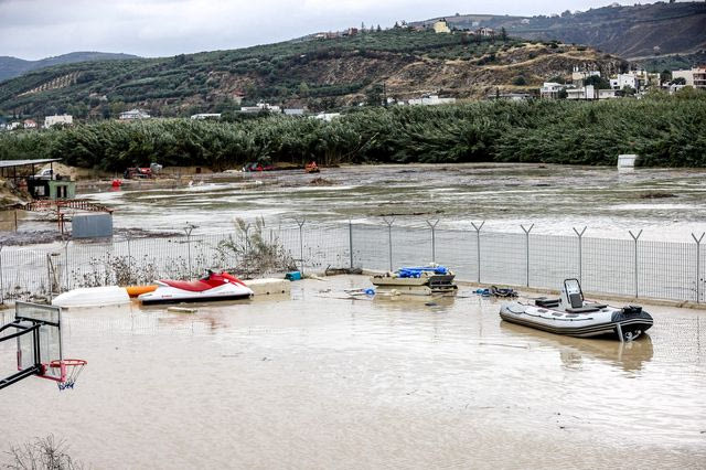
Dangerous weather conditions are battering Crete and are expected to persist through Sunday. Which other areas will be affected.
- 02 Οκτωβρίου 2026 10:19
The Hellenic National Meteorological Service’s emergency bulletin on dangerous weather conditions has been updated, with Crete once again at the centre of the severe weather through Sunday.
More specifically, heavy rain and thunderstorms will continue at intervals in the southern Aegean, mainly in Crete, until midday on Sunday (04-10-2026), while locally very strong northeasterly winds will persist in the Aegean until Saturday afternoon (03-10-2026).
More specifically:
Locally heavy rain and thunderstorms are forecast:
In Crete, mainly from Friday afternoon (02-10-2026) and on Saturday (03-10-2026).
Locally very strong northeasterly winds of force 8 to 9 on the Beaufort scale will blow in the Aegean until Saturday afternoon.
Sailing ban from Piraeus, Rafina and Lavrio
Strong winds are causing disruptions to ferry services, resulting in a sailing ban being in force at the ports of Piraeus, Rafina and Lavrio.
Morning sailings from Piraeus to the Cyclades will not operate, while the sailing ban remains in force until a further update, following the release of the new weather bulletin at around midday.
The situation is different for the Saronic Gulf islands, where conventional ferries are operating normally. As for hydrofoils, the situation varies by company. Passengers planning to travel by hydrofoil are advised to contact their ferry company, as some companies are operating services while others have suspended them.
Cancellations are also in effect from Rafina and Lavrio, where morning sailings are likewise not operating due to the adverse weather conditions.
As regards routes to Crete and the Dodecanese, there are currently no scheduled departures before midday.
Passengers planning to travel are advised to contact ferry companies or the local port authorities before heading to the ports, as the situation may change depending on how the winds develop.
Severe weather: 4 areas on “red alert” – Kolydas’ forecast
As Theodoros Kolydas says in a post about the weather over the coming days, the intense conditions will persist through Sunday, with southern Greece at the centre of the severe weather. More specifically, conditions are expected to worsen over the next few days, particularly in the Peloponnese, Kythira, Crete and the southern Aegean.
Theodoros Kolydas’ post
“Today’s update confirms that the main focus of the weather is gradually shifting towards southern Greece, where rainfall is expected to intensify over the coming days, particularly in the Peloponnese, Kythira, Crete and the southern Aegean. This development is not due solely to the familiar northerly flow bringing colder air masses towards the Aegean.
The upper atmosphere is also playing a decisive role, as an organised low at 500 hPa is deepening and increasingly affecting the eastern Mediterranean. Its presence is strengthening upward motion, dynamic instability and convergence, allowing the weather phenomena to become more intense and prolonged.
As a result, a more complex and dynamically supported weather pattern is developing in the south, with increased chances of heavy and persistent rainfall, mainly from Friday into Saturday.”
LIVE: Weather updates
Weather on Friday
The weather system spreads further towards the Ionian Sea and western and southern mainland Greece, while activity continues around Crete. The daily maximum is lower, at around 87 mm, but the geographical extent of the rainfall increases. This is essentially a day during which the system becomes more spatially organized.
Weather on Saturday
This is the day that stands out most on the map. ICON-EU forecasts a maximum of around 160 mm over 24 hours, the highest total of the five-day period. Heavy rainfall is expected across a large part of southern Greece, with particular emphasis on the southern Peloponnese–Kythira–Crete corridor and the surrounding seas. Based on this particular model run, this is the day with the greatest potential for very high local rainfall totals.
Weather on Sunday
Despite the system gradually shifting farther east, activity remains intense across southern Greece and especially around Crete. The maximum remains very high, at around 124 mm over 24 hours. This is significant because it is not just a single day of heavy rain, but successive 24-hour periods of substantial precipitation, increasing the risk of soil saturation and significant runoff in areas where large rainfall totals affect the same drainage basins.
Weather on Monday
A clear weakening is expected. The maximum drops to around 44 mm, while the bulk of the rainfall moves farther south and east. Rain is still expected, however, mainly around Crete and the southeastern Aegean.
Major destruction in Crete – One dead
Severe destruction was caused by the storm that hit Crete, with many areas battered by heavy rainfall, while one person was killed. Roads were damaged, homes were flooded and the Fire Service received more than 250 calls.
The 81-year-old livestock farmer who had been missing in Rethymno was found dead, buried under debris carried by the floodwaters. The elderly man had gone out to feed his animals and, according to the information available so far, was swept away while attempting to cross an area where the water level had risen dangerously.