May feels like… December: Mount Parnitha and Penteli covered in snow
Διαβάζεται σε 3'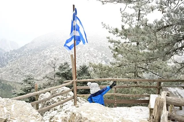
An unusual scene has been recorded on Mount Parnitha, where on May 3 snowfall exceeded 10 centimeters due to a strong cold front. Heavy snowfall was also reported in Dirfi and Mount Penteli.
- 03 Μαΐου 2026 12:38
The landscape resembles deep winter, yet the calendar reads May 3. Mount Parnitha was blanketed in snow in a rare phenomenon for the season, with snow exceeding 10 cm in several areas and transforming the scenery within just a few hours.
This is considered a strong cold spell for this time of year, recorded 86 years after a similar घटना in 1940. Snowfall has been observed in Dirfi, Parnitha, and Penteli at elevations above 800 meters, creating images more typical of winter than spring.
The sudden weather shift caught both visitors and residents off guard as early as May Day, as the spring-like conditions of previous days gave way to a December-like setting.
Trees and trails were covered by a thick layer of snow, while temperatures dropped noticeably, reinforcing the wintry feel.
The phenomenon is attributed to cold air masses affecting the country, causing this unseasonal snowfall.
Despite the impressive spectacle, authorities advise caution for those attempting to approach the area, as conditions may be dangerous due to slippery roads.
Due to the heavy snowfall, police have closed traffic on Parnitha Avenue from the cable car station upward.
Weather Forecast for Sunday (May 3)
Strong northerly winds are expected in the Aegean, reaching up to 8 Beaufort locally, and possibly up to 9 Beaufort in the southeastern areas by evening.
Eastern mainland regions and the Aegean will see clouds with local rain and mainly coastal thunderstorms. Conditions will improve inland by evening.
Elsewhere, partly cloudy skies with localized showers, mainly in mountainous areas during midday and afternoon.
Snowfall is expected in mountainous mainland areas.
Winds in western Greece will be northerly at 3–5 Beaufort (locally 6 in the Ionian), while in the east they will reach 4–6 Beaufort and 7–8 in the Aegean.
Temperatures will slightly drop in the southeastern Aegean, reaching 19–20°C in the west and 15–17°C elsewhere.
Regional Forecast Highlights
Macedonia & Thrace: Cloudy with local rain and possible storms (mainly coastal). Snow in mountainous areas. Improvement from the afternoon.
Ionian Islands, Epirus, Western Greece, Western Peloponnese: Partly cloudy with local showers in mountainous areas. Snow in higher elevations. Clearer weather at night.
Thessaly, Eastern Central Greece, Evia, Eastern Peloponnese: Increased cloud cover with rain and possible storms. Snow in mountainous areas. Improvement later in the day.
Cyclades & Crete: Cloudy with local rain and storms, easing overnight in the Cyclades.
Eastern Aegean Islands & Dodecanese: Cloudy with rain and storms, improving in northern areas by evening.
Attica: Increasing clouds with local rain and possible isolated storms. Improvement by evening. Temperatures between 9–16°C.
Thessaloniki: Cloudy with local showers and possible isolated storms until midday. Gradual improvement later. Temperatures between 8–16°C.
Outlook for the Coming Days
Monday (May 4): Improving weather across most of the country, with some clouds and light rain mainly in Crete and the southeastern islands.
Tuesday (May 5): Generally clear, with some clouds and possible brief showers in northeastern mountainous areas.
Wednesday (May 6): Mostly clear with occasional clouds.
Thursday (May 7): Thin clouds gradually thickening in western regions; no significant temperature change expected.