“White” New Year’s Eve with biting cold – Where the thermometer dropped to -8°C
Διαβάζεται σε 9'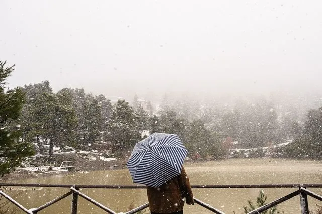
Low temperatures and snowfall, even in Attica, will mark the arrival of the new year. The forecast for the first day of 2026.
- 31 Δεκεμβρίου 2025 14:54
Greece will welcome 2026 under an intensely wintry backdrop and “biting” cold, as a strong cold air outbreak is currently affecting the country.
Speaking to Orange Press Agency, the Director of Research at the National Observatory of Athens, Kostas Lagouvardos, said:
“On New Year’s Eve, a strong cold air intrusion is underway across the country, which will significantly lower temperatures in all regions, mainly on New Year’s Eve and on New Year’s Day itself.”
Regarding the weather phenomena expected today, New Year’s Eve, Mr. Lagouvardos noted:
“We will also see some phenomena mainly in the eastern and southern parts of the country, meaning rain and snowfall even at low altitudes, such as in Evia, the Sporades, eastern Central Greece and Attica, as well as rain mainly in the Cyclades, Crete and the Dodecanese.”
For New Year’s Day, the forecast points to an improvement in weather conditions, but with very low temperatures.
“On New Year’s Day we expect the weather to gradually clear, with some phenomena remaining only in the Cyclades and Crete, while the rest of the country will see fair weather, but with very low temperatures,” he said, warning:
“We estimate that during the early morning hours of New Year’s Day, very strong frost will occur, mainly in areas of northern Greece.”
Forecast for light snowfall in Attica
Specifically for Attica, Mr. Lagouvardos stressed that
“on New Year’s Eve we will have cloudy conditions, with local sleet or even a little snow,” clarifying, however, that
“we do not believe the phenomena will be intense or cause problems; they will simply create a wintry atmosphere.”
Asked about the northern suburbs and Mount Parnitha, he pointed out:
“It is already snowing lightly on Parnitha. We will see some weak phenomena in the mountains, while in the northern suburbs we expect sleet and perhaps occasional light snowfall. Under no circumstances, however, do we expect snow accumulation.”
As for what follows, the bad weather appears set to ease soon.
“This two-day period of cold air intrusion will gradually come to an end from Friday and mainly over the weekend. With winds turning southerly, temperatures will rise,” Mr. Lagouvardos concluded.
Strong frost on Wednesday morning – Where the lowest temperatures were recorded
Frost, locally severe, was recorded during the morning hours of Wednesday 31/12, mainly in northern mainland regions, with the lowest minimum temperature measured at the meteorological station in Seli at -8.2°C.
According to the network of automatic weather stations of the National Observatory of Athens / meteo.gr, the eight lowest minimum temperatures recorded on the morning of Wednesday 31/12 are presented in the table below.
Evia covered in white – Machinery clearing the roads
Heavy snowfall began early on Wednesday morning in Evia, blanketing the northern part of the island in white. According to evima.gr, snow is falling in villages of the Dirfyon–Messapia municipality, from Steni towards Stropones, in the Agios area and in Setta of the Eretria municipality.
Regional authority machinery is operating on the Steni–Stropones road axis to keep roads open.
Hellenic National Meteorological Service (EMY) forecast for the coming days
WEDNESDAY 31-12-2025 (NEW YEAR’S EVE)
In the north, few clouds locally increased with local rain or sleet. In the rest of the country, increased cloud cover with local rain, while in the southern Aegean, thunderstorms will occur until midday. Light snowfall will affect mountainous and semi-mountainous areas of the mainland and Evia.
Winds will blow from northerly directions at 5 to 7 Beaufort and temporarily in the morning in the northeastern Aegean locally up to 8 Beaufort. In the south, westerly winds of the same intensity will prevail until midday.
Temperatures will drop significantly across almost the entire country, not exceeding 5–7°C in the north and 10–12°C in eastern mainland areas, while reaching 13–15°C in the west and northern Aegean islands and 16–18°C in Crete and the Dodecanese. Frost will occur during morning and evening hours on the mainland, locally severe in the north.
MACEDONIA, THRACE
Weather: Few clouds, locally increased, with local rain or sleet in Central Macedonia and locally light snowfall in mountainous and semi-mountainous areas. From the afternoon, temporary snowfall may occur even at low altitudes in parts of Eastern Macedonia.
Winds: Northerly 4–6 Beaufort, locally up to 7 Beaufort at sea, gradually weakening from midday.
Temperature: From -4°C to 5–7°C. In Western Macedonia from -8°C to 3°C.
IONIAN ISLANDS, EPIRUS, WESTERN CENTRAL GREECE, WESTERN PELOPONNESE
Weather: Few clouds, locally increased with local rain and light snowfall in mountainous and northern semi-mountainous areas. Phenomena will gradually cease from midday onwards, starting from the north.
Winds: North-northwesterly 3–5 Beaufort, locally up to 6 Beaufort in the Ionian, strengthening to 4–6 and locally 7 Beaufort.
Temperature: From 3°C to 13–15°C. In inland Epirus from -5°C to 3°C.
THESSALY, EASTERN CENTRAL GREECE, EVIA, EASTERN PELOPONNESE
Weather: Increased cloud cover with local rain, sleet in the north, and light snowfall in mountainous and semi-mountainous areas. Isolated thunderstorms may occur in the early morning hours in southern Peloponnese and the Kythera area.
Winds: Northerly 5–6 Beaufort, locally up to 7 Beaufort in eastern Thessaly, the Sporades and Evia, weakening from midday.
Temperature: From -1°C to 12°C, with maxima 3–4°C lower in the north.
CYCLADES, CRETE
Weather: Increased cloud cover with local rain and sporadic thunderstorms, quickly weakening.
Winds: Westerly 5–7 Beaufort, turning northerly 4–6 Beaufort, and from late afternoon 3–5 Beaufort.
Temperature: From 9°C to 15–17°C.
EASTERN AEGEAN ISLANDS – DODECANESE
Weather: Increased cloud cover with local rain and, until midday, sporadic thunderstorms in Samos–Ikaria and the Dodecanese. Late at night, snowfall is possible on the northernmost eastern Aegean islands.
Winds: Northerly 6–8 Beaufort in the eastern Aegean, weakening later, while in the Dodecanese westerly 5–7 Beaufort, gradually turning north-northwesterly.
Temperature: From 5°C to 13°C, and in the Dodecanese from 12°C to 18°C.
ATTICA
Weather: Increased cloud cover with intermittent local rain. Light snowfall will initially occur in mountainous areas and, from evening, temporarily in areas above approximately 350–400 meters.
Winds: Northerly 4–5 Beaufort, locally up to 6 Beaufort in eastern parts until afternoon.
Temperature: From 3°C to 11°C.
THESSALONIKI
Weather: Generally clear, with temporary cloud cover in the morning.
Winds: North-northwesterly 5–6 Beaufort, locally up to 7 Beaufort at sea in the morning.
Temperature: From -1°C to 6°C.
THURSDAY 01-01-2026 (NEW YEAR’S DAY)
In the west and north, generally fair weather, with few local clouds during the morning in eastern Macedonia, Thrace and eastern Halkidiki, where light snowfall will occur in mountainous and semi-mountainous areas and sleet at lower altitudes.
In the rest of the country, few clouds locally increased with local rain, sleet in northern areas and temporary snowfall in mountainous and central and northern semi-mountainous areas. After midday, phenomena will cease in most areas, continuing only in Crete until evening.
Winds from northerly directions at 4–5 Beaufort and up to 6 Beaufort at sea, gradually weakening from the afternoon.
Temperatures will drop slightly further, mainly in the south, remaining low nationwide. Maximum temperatures will not exceed 5–6°C in the north, 7–10°C in eastern mainland areas, 11–13°C elsewhere, and locally 14–15°C in southern Crete and the Dodecanese.
Frost will occur during morning and evening hours on the mainland, locally severe in the north.
FRIDAY 02-01-2026
Initially, generally fair weather across most of the country, with few clouds increasing rapidly in the west. From the afternoon, local rain will occur in the northern Ionian, Epirus, western Macedonia and temporarily in parts of eastern Macedonia and Thrace, with sporadic thunderstorms in the Ionian. Overnight, phenomena will spread to western Central Greece and western Peloponnese.
Snowfall will occur from the afternoon in the mountains of Epirus and temporarily at night in mountainous areas of eastern Macedonia and Thrace.
Winds will be southerly to southwesterly at 3–5 Beaufort, strengthening in the Ionian and northeastern Aegean from the afternoon.
Temperatures will rise in terms of maximum values, though frost will still occur early in the morning in mainland areas, locally severe in the north.
SATURDAY 03-01-2026
In the west, cloudy with local rain and sporadic thunderstorms. Elsewhere, clouds locally increased with local rain mainly in the eastern Aegean and Thrace, where isolated thunderstorms are possible.
Temporary snowfall will occur in western mainland mountainous areas during the morning.
Winds will be southerly to southwesterly at 5–6 Beaufort, 7 Beaufort at sea and locally 8 Beaufort in the northern Aegean.
Temperatures will rise.
SUNDAY 04-01-2026
Thin clouds locally and at times denser. Local rain will mainly affect the west, south, eastern Aegean and Thrace.
Winds will be southerly to southwesterly at 5–6 Beaufort, 7 Beaufort at sea and locally 8 Beaufort in the northern Aegean.
Temperatures will rise further.