Greece on wildfire alert as gale-force winds fuel extreme fire danger
Διαβάζεται σε 5'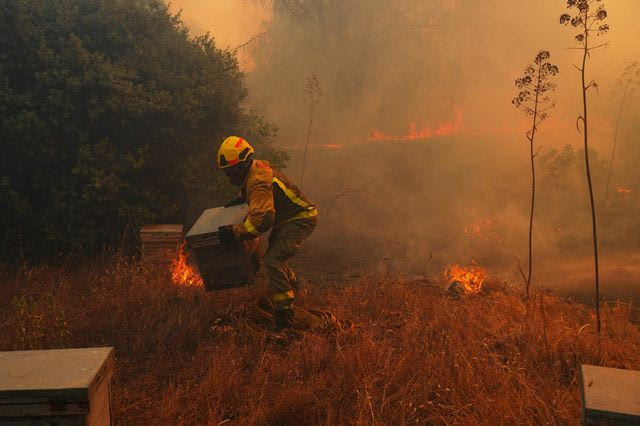
Several parts of Greece are at the highest wildfire risk level on Friday, with powerful northerly winds expected to reach 9 Beaufort and gusts exceeding 110 km/h in parts of the Aegean.
- 14 Αυγούστου 2026 09:32
Several regions across Greece remain on red alert for wildfires on Friday (14/08), as gale-force northerly winds create particularly dangerous fire-weather conditions.
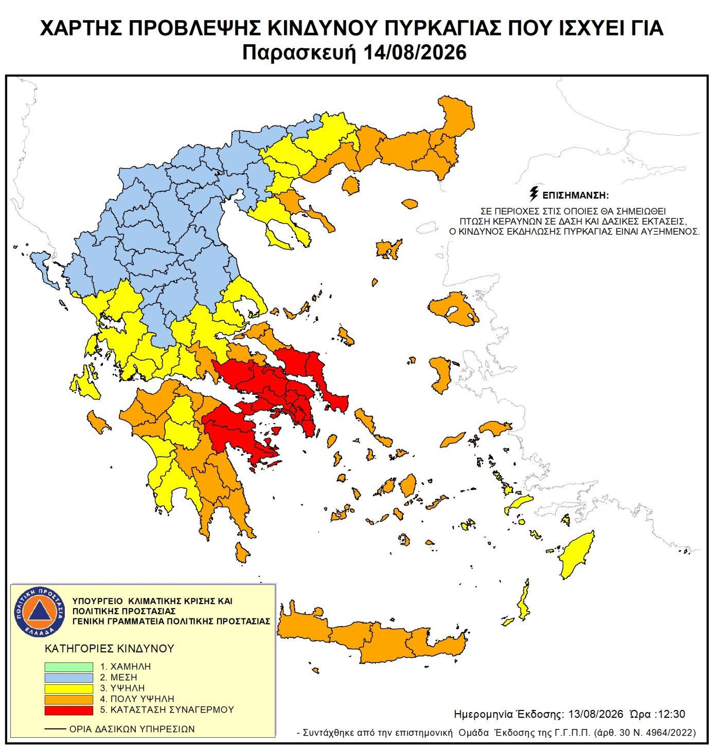
According to the Civil Protection General Secretariat’s Fire Risk Forecast Map, Attica, Boeotia and Argolis, as well as parts of Evia and Corinthia, are at Category 5, the highest level of wildfire risk.
At the same time, large parts of mainland and island Greece are under Category 4, indicating a very high wildfire risk.
The key concern on Friday is the further strengthening of the winds. Greece’s Risk Assessment Committee met on Thursday (13/08) to assess the situation, with winds expected to peak on Friday and reach up to 9 Beaufort in some areas.
Areas facing extreme wildfire risk
According to the Civil Protection fire risk map, Category 5 conditions are forecast in parts of:
- Attica
- Boeotia
- Evia
- Argolis
- Corinthia
Meanwhile, a very high wildfire risk – Category 4 – extends across a large part of the country, including:
- Attica Region (Kythera)
- Peloponnese Region (Corinthia, Arcadia and Laconia)
- Western Greece Region (Achaia and Ilia)
- Ionian Islands Region (Zakynthos)
- Central Greece Region (Phocis, Phthiotis, Evia and Skyros)
- Thessaly Region (Sporades)
- North Aegean Region
- Central Macedonia Region (Halkidiki and Mount Athos)
- Eastern Macedonia and Thrace Region (Kavala, Thasos, Xanthi, Rhodope, Evros and Samothrace)
- South Aegean Region (Cyclades)
- Crete
Civil Protection authorities have placed the relevant state agencies, regional authorities and municipalities on heightened alert to ensure an immediate response to any wildfire outbreak.
Risk Assessment Committee: Winds to peak on Friday
Civil Protection Secretary-General Nikos Papaefstathiou convened the Risk Assessment Committee on Thursday (13/08), as the gale-force winds already affecting much of the country were forecast to strengthen further.
According to the committee’s scientists, Friday is expected to be the most difficult day.
In Thrace, northerly and northeasterly winds are forecast at 6 to 7 Beaufort, while across the North and East Aegean islands they will reach 7 to 8 Beaufort and locally 9 Beaufort.
Particularly strong winds are also expected in Attica, Boeotia and Evia, reaching 7 to 8 Beaufort. In eastern and southern Attica and southern Evia, winds could locally reach 9 Beaufort.
Similar conditions are expected across the central Aegean and the Cyclades, with winds of 7 to 8 Beaufort and locally 9 Beaufort.
In the eastern and southern Peloponnese and Kythera, winds are forecast to reach 8 Beaufort in some areas, while Crete will see winds of 5 to 7 Beaufort and locally 8 Beaufort in the west.
The forecast by the Hellenic National Meteorological Service (EMY) also points to exceptionally strong northerly winds, reaching 8 and possibly 9 Beaufort in the Aegean.
Kolydas: Wind gusts of up to 113 km/h on Friday
Meteorologist Thodoris Kolydas has highlighted the importance of wind gusts, noting that the Beaufort scale alone does not provide the full picture of the conditions expected at sea.
According to data presented through his Wind Intelligence charts, Friday will be the more difficult of the two days for sea travel.
In the central Aegean, the Kafireas Strait and the South Evian Gulf, sustained winds are expected to reach 7 and locally 8 Beaufort, while gusts could range between 103 and 113 km/h.
In the South Evian Gulf, maximum gusts could reach 113 km/h, while gusts of around 103 km/h are forecast for the Kafireas Strait and the central Aegean. Very strong gusts are also expected in the northeastern and northwestern Aegean.
Kolydas stressed that these will not simply be brief bursts of strong wind, as very strong winds are expected to persist for several hours in a number of maritime areas.
Strong meltemi winds to persist on August 15
The difficult conditions will continue into Saturday, August 15, traditionally one of the busiest days of the summer for ferry travel in Greece.
The Risk Assessment Committee forecasts winds of 6 to 8 Beaufort across the North and East Aegean islands, while in Attica, Boeotia and Evia they will reach 6 to 7 Beaufort and temporarily up to 8 Beaufort locally.
In the central Aegean and northern Cyclades, winds are expected to reach 7 to 8 Beaufort and temporarily 9 Beaufort in some areas.
According to data presented by Kolydas, the focus on Saturday will shift towards the central and southern Aegean, particularly the Cretan Sea, where gusts could reach as high as 126 km/h.
Maximum gusts in the central Aegean and Kafireas Strait are estimated at around 97 km/h, while in the northeastern Aegean they could reach approximately 103 km/h.
Advice for ferry passengers
Passengers planning to travel to the Cyclades, Dodecanese, Crete or other Aegean destinations are advised to closely monitor announcements from port authorities and ferry companies before departure.
As Kolydas notes, it is important to consider not only the average wind strength measured on the Beaufort scale but also the duration and peak intensity of gusts, which can be significantly stronger.
The conditions could lead to delays or changes to ferry schedules, particularly for smaller vessels and high-speed ferries.