Severe Weather: Flooding and Destruction on Skiathos and Evia – Eight Regions on Red Alert
Διαβάζεται σε 8'
Severe weather is sweeping across Greece, causing flooding, widespread damage and travel disruptions. Eight regions are on red alert, while strong winds have prompted ferry sailing bans.
- 14 Οκτωβρίου 2026 10:33
Greece remains in the grip of dangerous weather conditions, with torrential rain, gale-force winds reaching up to Force 10 on the Beaufort scale, and raging floodwaters causing widespread disruption, flooding and power outages.
Skiathos, Evia and the Sporades islands have been among the hardest-hit areas, while Attica has also been severely affected, with several roads closed to traffic.
Concerns are mounting over the coming hours, as Attica and seven other regions have been placed on Red Code alert due to the risk of dangerous weather conditions.
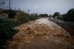
Dramatic scenes unfolded on Skiathos overnight, as the island’s main streets turned into raging rivers..
Floodwaters swept into dozens of shops and homes, while parked vehicles were carried away by the force of the raging torrents. Serious damage was reported to the road network in the areas of Agia Paraskevi and Platanias, while the ring road became almost impassable.
Meanwhile, a major fault in the electricity network left half the island without power.
Shortly after midnight, Greece’s Civil Protection authorities sent an emergency alert through the 112 system, urging residents and visitors to drastically limit their movements.
In response to the scale of the destruction, Mayor Thodoris Tzoumas announced plans to request that the island be declared in a state of emergency, while local authorities issued a strong warning to residents to stay away from streams and flooded roads.
Conditions were also particularly difficult on Evia, where the Hellenic National Meteorological Service (EMY) maintained its highest warning level for severe, prolonged thunderstorms.
Early in the morning, residents in the Politika area received a 112 emergency alert, urging them to exercise extreme caution when travelling. Meanwhile, the Fire Service received dozens of calls and carried out continuous operations to remove trees brought down by the powerful winds.
According to evima.gr, an auxiliary bridge collapsed in the Kyparissi area, at a location known as “Pethamenos,” in the Municipality of Mantoudi–Limni–Agia Anna, as a result of the severe weather.

In Attica, the severe weather caused widespread flooding and significant disruption to the road network. The highest rainfall was recorded in Perama, with 85 millimetres, while problems were also reported in Mandra, Salamina, Piraeus and central Athens.
Traffic police were forced to introduce diversions and temporary changes to traffic flow, including on the Old Athens–Corinth National Road in Megara, as well as in Pikermi and on Omiridou Skylitsi Street in Piraeus.
Ferry Services Suspended as Gale-Force Winds Reach 10 on the Beaufort Scale
Winds reaching Force 9 and temporarily Force 10 on the Beaufort scale in the Aegean Sea have caused major disruption to ferry services.
A sailing ban is in effect at the ports of Piraeus and Lavrio, while only certain conventional ferry services are operating in the Saronic Gulf, with high-speed vessels remaining docked.
Meanwhile, ferry services on the Agia Marina–Nea Styra and Arkitsa–Aidipsos routes have also been suspended.
Although morning ferry departures from Rafina proceeded as scheduled, port authorities are advising passengers to contact their travel agencies before departure to check for any last-minute schedule changes.
Live Updates on the Severe Weather
Emergency Weather Warning Upgraded
Earlier on Tuesday, the Hellenic National Meteorological Service (EMY) upgraded the emergency weather warning it had issued on Monday.
Heavy rain and thunderstorms, with the possibility of localized hailstorms, are expected across most of Greece, particularly in coastal and maritime areas, on Tuesday (October 13, 2026) and Wednesday (October 14, 2026).
Meanwhile, locally violent northeasterly winds are forecast in the northern Aegean from Tuesday evening (October 13).
More specifically:
1. Locally heavy rain and thunderstorms are forecast:
A. Tuesday, October 13, 2026
a) Temporarily in the Ionian Islands (Lefkada, Kefalonia and Zakynthos), western Central Greece and the western and southern Peloponnese until the evening (orange warning).
b) In Halkidiki from midday (orange warning).
c) In the Sporades islands and eastern Thessaly (Magnesia) from the afternoon (orange warning). The weather phenomena in these areas are expected to be particularly intense and prolonged.
d) In Evia from the afternoon (red warning). The weather phenomena in this area are expected to be particularly intense and prolonged.
e) In the northeastern Peloponnese, eastern Central Greece (including Attica) and the Cyclades (mainly their western and northern parts) from late afternoon (orange warning).
f) In the Dodecanese from late at night (orange warning).
g) In Crete (mainly the regional units of Chania and Rethymno) from the evening (orange warning).
B. Wednesday, October 14, 2026
a) In Evia until late afternoon (red warning).
b) Temporarily in the northeastern Peloponnese, eastern Central Greece (including Attica) and the Cyclades (mainly their western and northern parts) until the early morning hours (orange warning).
c) In Halkidiki until the morning hours (orange warning).
d) In the Sporades islands and eastern Thessaly (Magnesia) until the afternoon (orange warning).
e) In the Dodecanese until the afternoon (orange warning).
f) In Crete (mainly Chania and Rethymno) until late at night (orange warning).
2. Locally violent northeasterly winds
Northeasterly winds reaching Force 8 to 9 and temporarily up to Force 10 on the Beaufort scale are expected initially in the northern Aegean, gradually extending to the central Aegean, from Tuesday evening until late Wednesday night.
Weather Forecast for Wednesday (October 14)
In eastern Greece, increased cloud cover is expected, with rain and scattered thunderstorms, mainly in central and southern areas. The storms will be locally severe in Halkidiki, Evia, eastern Thessaly, the Sporades, Crete and the Dodecanese.
In western Greece, partly cloudy skies are expected, with temporarily increased cloud cover and local rainfall until midday.
Winds will blow from northerly directions at Force 6 to 8, reaching Force 8 to 9 locally in the Aegean and temporarily up to Force 10 on the Beaufort scale.
Temperatures will reach 16–18°C in central and northern mainland Greece, 19–22°C in other areas, and 23–24°C in western mainland Greece and the Dodecanese.
Weather Forecast for Thursday (October 15)
In Crete, cloudy skies are expected, with local rainfall and scattered thunderstorms, which will be locally intense until midday.
In Evia, eastern Central Greece, the Cyclades and the eastern Aegean, cloudy conditions with brief local rainfall are forecast early in the morning, followed by a rapid improvement from midday.
Elsewhere in Greece, conditions will be mostly clear, with clouds developing over northern mainland areas from the evening.
Winds will blow from northerly directions, reaching Force 6 to 7 in the Aegean and temporarily Force 8 until midday. Elsewhere, winds will range from Force 3 to 5.
Temperatures will rise slightly, reaching 20–23°C in most areas and locally 24°C in western mainland Greece and the Dodecanese.
Weather Forecast for Friday (October 16)
Another change in weather conditions is expected on Friday, with rain and thunderstorms affecting several parts of Greece.
In the Dodecanese and Crete, increased cloud cover is forecast, with local rainfall and isolated thunderstorms, mainly in southeastern areas. Conditions are expected to improve from the afternoon.
Elsewhere in Greece, cloud cover will temporarily increase, initially in northern areas and gradually spreading to central and southern regions, bringing local rainfall and scattered thunderstorms from the afternoon.
Light snowfall is also possible in mountainous areas of northern and central Greece.
Winds will blow from northerly directions at Force 4 to 5, reaching Force 6 and locally Force 7 in the Ionian Sea and northern Aegean.
The development of the weather conditions, particularly in areas where severe thunderstorms and gale-force winds are expected, requires caution, as the emergency weather warning remains in effect.
Weather Forecast for Saturday (October 17)
Initially, local rainfall and isolated thunderstorms are expected in eastern Thessaly, the Sporades, Evia, Central Greece, the Peloponnese and the southern Ionian Sea.
From midday, the weather system will gradually move southward, affecting the Cyclades, Crete and the Dodecanese.
Elsewhere in Greece, conditions will be generally clear, with some temporarily increased cloud cover.
Winds will initially blow from the east and northeast at Force 4 to 5, reaching Force 6 locally over southern seas, before gradually weakening from the afternoon.
Temperatures are not expected to change significantly.