Glyfada: Devastating images after the deadly storm
Διαβάζεται σε 7'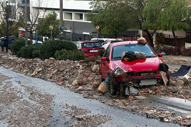
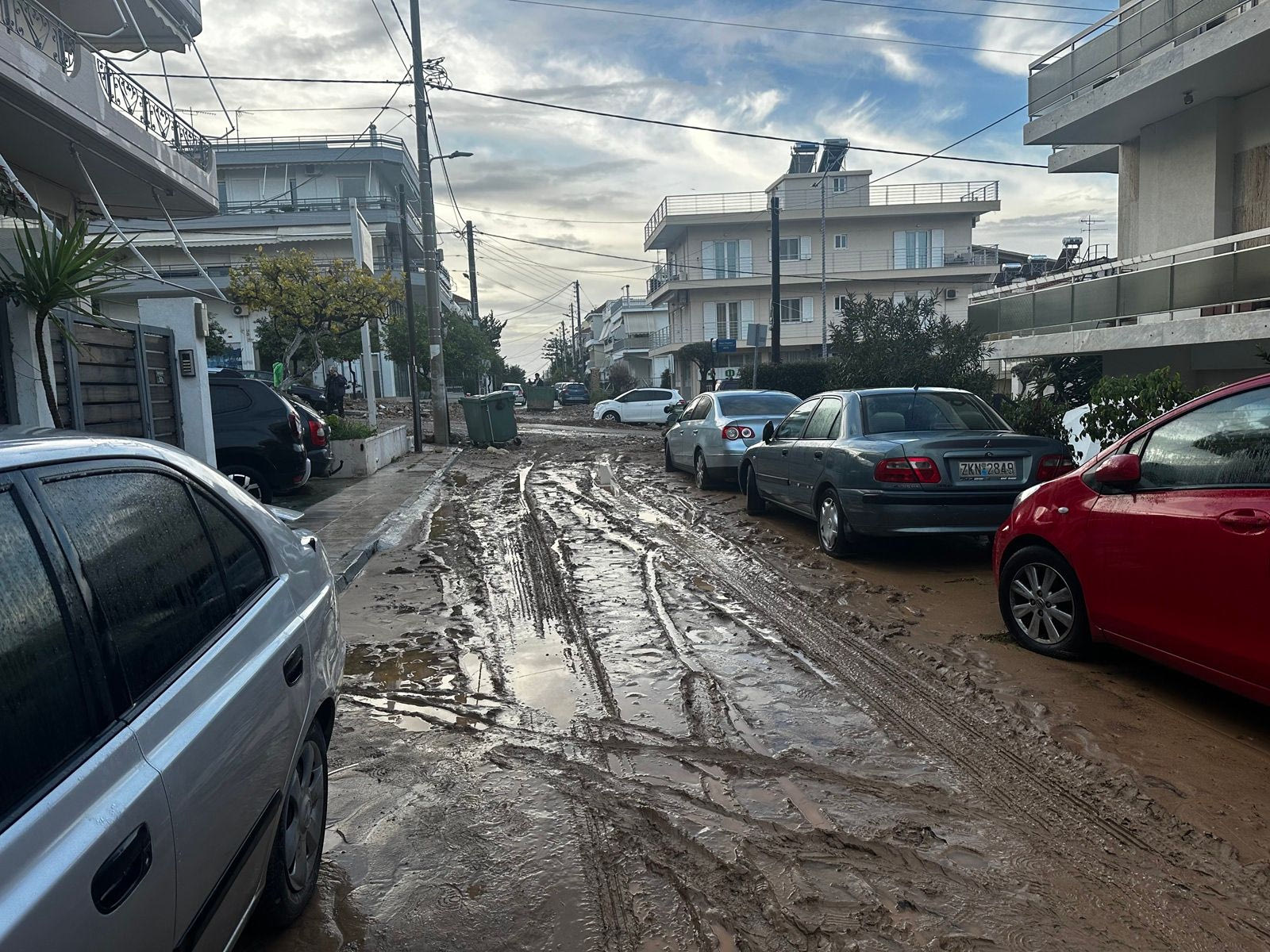
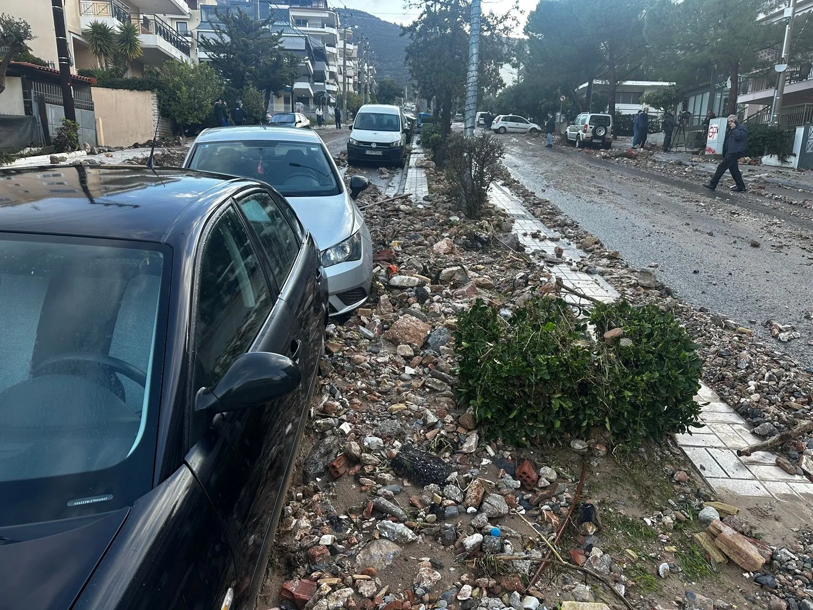
Vehicles impaled on poles, huge stones, and mud everywhere create a scene of destruction in Upper Glyfada, following the deadly storm.
- 22 Ιανουαρίου 2026 11:00
Devastating images are recorded in Upper Glyfada following the deadly storm, which left widespread destruction and a landscape of complete disintegration.
It is reminded that on Wednesday (21/01), during the onset of the storm, a 56-year-old woman lost her life in Upper Glyfada when a vehicle was swept away by the raging waters and trapped on top of her. The incident occurred on Kyriellou Methodiou Street 14. Her body was found under a car, extricated by the Fire Brigade, and transported to the Asclepius hospital in Voula.
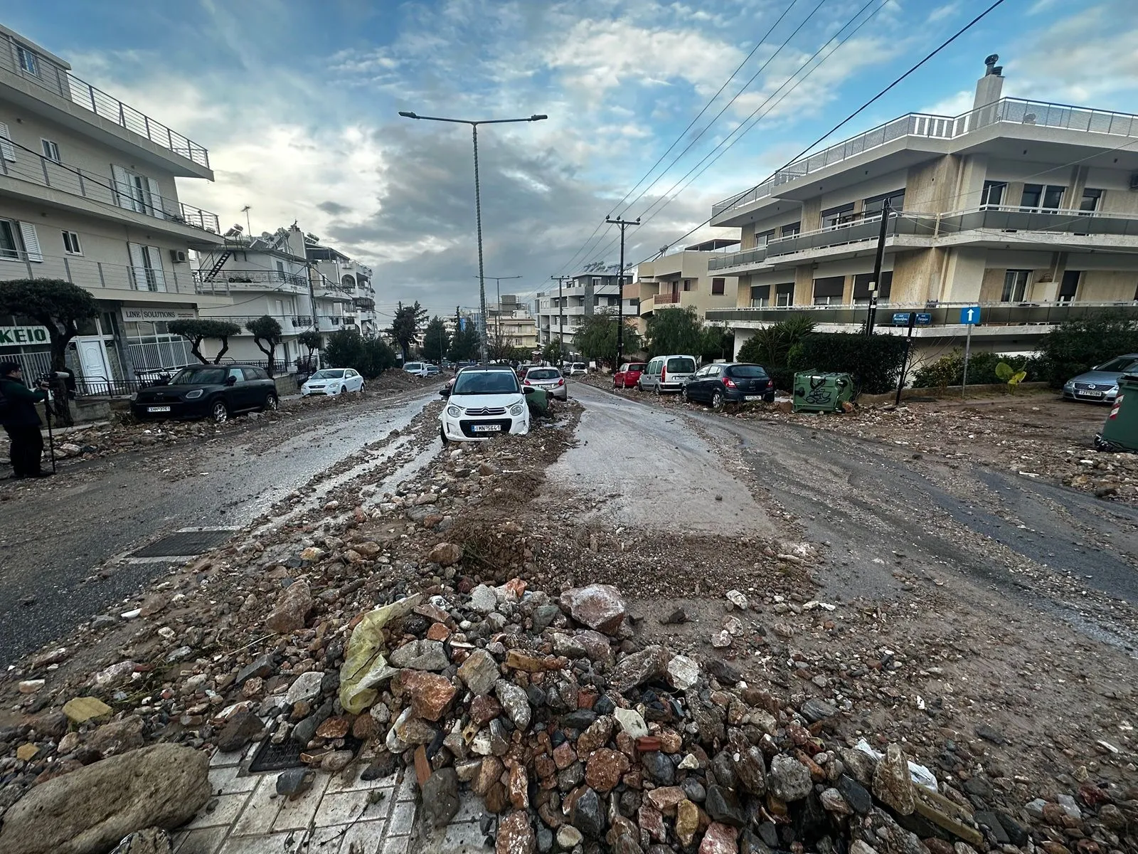
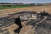
Today, vehicles impaled on poles, huge stones, and debris create a scene of chaos, with the area resembling a bombed landscape. The raging waters descending from the mountain carried large stones and dirt, causing severe damage to infrastructure and parked cars on Antheon Street and Metsovo Street (extension of Antheon), where the worst destruction is reported. Since the early morning hours, residents and municipal crews have been working tirelessly, while excavation machines are working non-stop to clear Antheon Street. For now, vehicles attempting to ascend or descend the road risk damage as the debris has not been fully removed from the road.
Many large stones have been impaled on vehicles, while several others have been swept away by the waters and remain immobilized in the middle of the road, unable to be moved. In many cases, dirt, trash, and stones have accumulated under parked cars, causing some to even be raised. Meanwhile, vehicle owners are trying to “dig out” their cars from the debris with shovels. The area is flooded with mud, paralyzing the daily life of residents.
Speaking to NEWS 24/7, residents explain that it has been over two decades since they witnessed scenes similar to those that unfolded last night. “I don’t remember seeing anything like this in the last 20 years,” said a local resident.
Business owners and residents of Upper Glyfada on Antheon and surrounding streets are still trying to remove whatever they can from their yards, entrances, and the road, even by hand. A resident explains to NEWS 24/7 that the continuous expansion of the residential area towards the mountain, combined with two fires that previously destroyed a large part of the natural landscape, has made Antheon Street the only outlet for the water that accumulates on the mountain during storms like the one that occurred yesterday.
Rainfall records in Attica and the Peloponnese:
According to the network of meteorological stations of the National Observatory of Athens, rainfall levels were particularly high. In Attica, more than 140 millimeters of rain were recorded, with the highest values in areas like Papagos, Vyronas, and Vlychada.
Significant rainfall was also recorded in Taktykopoli Troizinia, Dymima Argolis, Spetses, and areas of Laconia.
How the storm will move on Thursday (22/1)
The intense storm that hit the country on Wednesday is expected to last until Thursday morning, after which it will be confined to the eastern areas.
Specifically, strong phenomena are expected in the Eastern Aegean, with heavy rain and thunderstorms until the midday hours in the Northern and Eastern Aegean islands and until noon in the Dodecanese, accompanied by very strong winds.
In the western regions, including the Peloponnese, the Cyclades, Crete, the Dodecanese, the Northern and Eastern Aegean islands, and eastern Macedonia and Thrace until the morning hours, clouds with rain and sporadic thunderstorms are expected. The phenomena will be strong, particularly in the Northern and Eastern Aegean islands until the midday hours and in the Dodecanese until noon.
In other areas, temporary increases in cloudiness are expected, with local rain and isolated thunderstorms.
Temporary snowfalls will occur in the mountainous areas, mainly in central and southern regions.
The temperature will experience a slight increase. It will reach 08-10°C in the northern mainland, 12-14°C in the remaining areas, and 17-18°C (locally 19°C) in Crete, the Cyclades, and the Dodecanese.
Macedonia, Thrace:
Weather: Cloudy, with local rain or sleet and sporadic thunderstorms, mainly in the coastal areas. In Eastern Macedonia, the phenomena will subside quickly and will be confined to the eastern parts of Thrace. Snowfall will occur in the mountains until the early morning hours.
Winds: East-northeasterly 4-6 in the west and from northern directions 3-5 in the east. Variable from the afternoon, 3-4.
Temperature: 1 to 9°C, with the maximum 3-4°C lower in Western Macedonia.
Ionian Islands, Epirus, Western Sterea, Western Peloponnese:
Weather: Cloudy in Epirus, with local rain. In other areas, increased cloudiness with local rain and sporadic thunderstorms. Snowfall will occur in the mountains until noon.
Winds: South-southeasterly 4-6 in the north, and southwesterly with the same intensity in the south. From midday, the winds will gradually weaken to 3-5 and shift in the south to northwesterly.
Temperature: 7 to 14°C, with 3-5°C lower in Epirus.
Thessaly, Eastern Sterea, Euboea, Eastern Peloponnese:
Weather: Local clouds in Thessaly and the Sporades. In other areas, increased cloudiness with local rain and sporadic thunderstorms, initially in Eastern
Peloponnese and later in Eastern StereaSnowfall will occur in the mountains of Eastern Peloponnese until the morning hours.
Winds: Northwest 3-5 in the north, variable 3-4 from midday. In the south, southerly 4-6.
Temperature: 4 to 15°C, with a 3-4°C lower maximum in the north.
Cyclades, Crete:
Weather: Increased cloudiness with local rain and sporadic thunderstorms.
Winds: Southerly southwesterly 5-7, and southeast 8-9 in the east until morning.
Temperature: 12 to 17°C.
Eastern Aegean Islands – Dodecanese:
Weather: Cloudy, with local rain and sporadic thunderstorms. The phenomena will be particularly intense in the Eastern Aegean islands until the midday hours and in the Dodecanese until noon.
Winds: Southeasterly, 6-8 in the north, quickly shifting to south-southwesterly 4-6, and 8-10 in the south. The winds will gradually shift to south-southwesterly from the midday hours and weaken.
Temperature: 11 to 19°C, with the maximum 3-4°C lower in the north.
Attica:
Weather: Cloudy, with increasing cloudiness and local rain after midday.
Winds: Variable 3-4, gradually from southerly directions 3-5.
Temperature: 7 to 15°C.
Thessaloniki:
Weather: Cloudy with temporary increases in cloud cover.
Winds: North-northwesterly 3-4, variable and weak from midday.
Temperature: 3 to 9°C.