Erminio swept across the country – One dead and multiple problems
Διαβάζεται σε 7'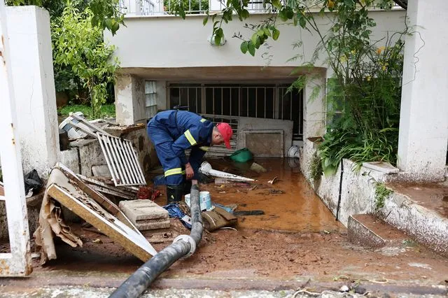
The passage of storm “Erminio” was sweeping across many regions of the country, including Attica, where a man lost his life in the area of Nea Makri.
- 02 Απριλίου 2026 12:06
One fatality and extensive material damage have been left in the wake of storm Erminio, which continues to affect the entire country with heavy rainfall, thunderstorms and gale-force winds, albeit with less intensity compared to the previous day.
The tragic incident occurred in the early hours of Thursday (2/4), when firefighters located the man beneath a passenger car in Nea Makri, which had been swept away by floodwaters.
The rescue operation involved four firefighters and two vehicles, according to a post by the Fire Service. According to reports, the victim was a man of Polish origin who was living in a basement apartment and attempted to escape when floodwaters began to inundate his home.
However, upon reaching the street, he was swept away and became trapped under a parked vehicle, which had likely also been carried by the rushing waters.
Hundreds of calls to the Fire Service
It is noted that heavy rainfall, thunderstorms, strong winds and local hailstorms continue to affect most parts of the country, prompting emergency alerts (112) in several regions since yesterday, with authorities urging citizens to limit movements and follow official instructions.
Due to the severe weather conditions in Attica, the Fire Service has received hundreds of calls for fallen trees and other incidents, while significant problems have been recorded in the southern suburbs.
In detail:
- In the Region of Attica: 483 calls, including 191 tree removals, 168 water pumpings, 91 object removals and 33 rescues
- In the Region of Peloponnese: 27 calls, including 5 tree removals, 1 object removal and 21 water pumpings
- In the Region of North Aegean: 14 calls, including 8 tree removals and 6 water pumpings
- In the Region of South Aegean: 60 calls, including 28 tree removals and 4 object removals
- In the Region of Crete: 90 calls, including 23 tree removals and 6 object removals
In recent hours, heavy rainfall has made the situation particularly difficult in eastern Attica and the northern suburbs, where roads have turned into torrents. On Marathon Avenue, near Rafina, vehicles and even a bus were immobilized due to high water levels.
On the island of Poros, roads turned into rivers, a small bridge collapsed and vehicles were swept away. Schools on the island remain closed.
Significant problems have also been reported on other islands, such as Crete and Rhodes.
Video from the storm’s impact across the country
Updated Emergency Weather Warning – What it says for Thursday
The Emergency Weather Warning issued on Monday (30-03-26) with a red alert has been updated based on the latest forecast data and, for Thursday (02-04-2026), downgraded to an orange alert for severe weather.
More specifically: Prolonged and intense rainfall and thunderstorms, possibly accompanied by local hailstorms, are expected today in many areas of northern and northeastern Greece and gradually from midday in the southwest and Crete.
Gale-force winds of 8 to 9 Beaufort will blow in northeastern Greece (Chalkidiki, eastern Macedonia, Thrace and the Lemnos area) until midday.
At the same time, elevated concentrations of African dust are expected today, particularly in southern regions, especially Crete, the Cyclades and the Dodecanese.
Heavy rain and thunderstorms are forecast:
- In eastern Macedonia, Thrace and the regional units of central Macedonia (Chalkidiki and Serres) until early afternoon
- In northern Evia, Magnesia, the Sporades and Lemnos until late morning
- In western and southern Peloponnese from midday until late at night
- In Crete (mainly western and southern parts) from early afternoon until late at night
Detailed weather forecast by the Hellenic National Meteorological Service
Thursday Forecast
MACEDONIA, THRACE
Weather: Cloudy with rain and scattered thunderstorms. Locally intense phenomena in Chalkidiki, Serres, eastern Macedonia and Thrace until late afternoon. Snowfall in mountainous areas, heavy in western and eastern Macedonia.
Winds: Easterly to northeasterly 4–6, locally 7, at sea up to 8 Beaufort. Gradually turning northerly in the west and southerly in the east.
Temperature: 8 to 15°C (4–5°C lower in western Macedonia).
IONIAN ISLANDS, EPIRUS, WESTERN CENTRAL GREECE, WESTERN PELOPONNESE
Weather: Cloudy with rain and thunderstorms, locally intense in western and southern Peloponnese until late night. Snowfall in mountainous areas until afternoon, heavy in Epirus in the morning.
Winds: South to southeast 4–6, in the south southwest up to 7 Beaufort.
Temperature: 9 to 16–17°C.
THESSALY, EASTERN CENTRAL GREECE, EVIA, EASTERN PELOPONNESE
Weather: Cloudy with rain and thunderstorms, locally intense until midday in eastern Central Greece, northern Evia and eastern Thessaly (including Larissa, Magnesia and the Sporades).
Winds: South to southwest 5–7, with northeasterly winds in Thessaly in the morning.
Temperature: 10 to 16–17°C.
CYCLADES, CRETE
Weather: Cloudy with rain and thunderstorms, locally intense in Crete (mainly west and south) from midday until late night.
Winds: Southwest 5–7, locally 8 Beaufort, weakening in the evening.
Temperature: 14 to 19°C.
EAST AEGEAN ISLANDS – DODECANESE
Weather: Cloudy with rain and thunderstorms. Phenomena will be locally intense in the East Aegean from late afternoon and in the Dodecanese in the early hours.
Winds: South to southwest 6–7, temporarily up to 8 Beaufort in the north in the morning.
Temperature: 14 to 18–19°C (2–3°C lower in the north).
ATTICA
Weather: Cloudy with rain and thunderstorms, locally intense in the early morning, gradually weakening from midday.
Winds: Southwest 5–6, locally 7 Beaufort in the east.
Temperature: 12 to 16°C.
THESSALONIKI
Weather: Cloudy with rain and scattered thunderstorms, possibly locally intense.
Winds: Easterly 4–6 Beaufort, quickly turning north-northwesterly and weakening from midday.
Temperature: 10 to 15°C.
Friday Forecast
Cloudy with local rain and scattered thunderstorms, mainly in western and southern Peloponnese, the East Aegean islands, Dodecanese, Cyclades and Crete. Phenomena will gradually weaken in the west from the afternoon.
Elsewhere, temporarily increased cloudiness with local rain and isolated thunderstorms in mainland areas during midday–afternoon hours.
Visibility will be locally limited in western mainland areas at night.
Winds: Westerly 4–6 Beaufort, temporarily up to 7 in southern seas.
Temperature: No significant change.
Saturday Forecast
Cloudy in the East Aegean islands and Dodecanese with local rain and scattered thunderstorms, easing from midday. Elsewhere, temporarily increased cloudiness with local rain and isolated thunderstorms from midday, mainly in eastern Macedonia, Thrace, Peloponnese and Crete.
Visibility will be locally limited in western mainland areas in the morning.
Winds: West-northwesterly 3–5, locally 6 Beaufort at sea. In the east, northerly 3–5, locally 6 Beaufort in the northern Aegean from the evening.
Temperature: No significant change.
Sunday Forecast
Cloudy in Thessaly, Sporades, eastern Central Greece, Evia, southern Peloponnese and southern island regions, with local rain and isolated thunderstorms, improving from the afternoon. Elsewhere, generally fair with clouds increasing during midday–afternoon, bringing local rain and isolated storms inland.
Winds: Northerly, 3–5 in the west, 4–6 in the east and locally 7 Beaufort in the Aegean.
Temperature: No significant change.